^Top image: On Oct. 7, 2016, people in Les Cayes, Haiti, search through the wreckage left by Hurricane Matthew days earlier. Credit: Julien Mulliez, UK Department for International Development (licensed under CC BY 2.0)
This past weekend, Hurricane Matthew ravaged the southeast Atlantic coast of the United States, causing flooding and accidents that killed at least 33 people in Florida, Georgia, South Carolina, North Carolina, and Virginia. The storm then weakened and turned out to sea, but flooding from heavy rains and storm surges continued in a number of areas. Matthew’s worst destruction, however, came days earlier when the hurricane made landfall in Haiti. There, the storm killed around 1,000 people and triggered a number of cholera cases. Deaths were also reported at sea and in the Dominican Republic, which shares the island of Hispaniola with Haiti.
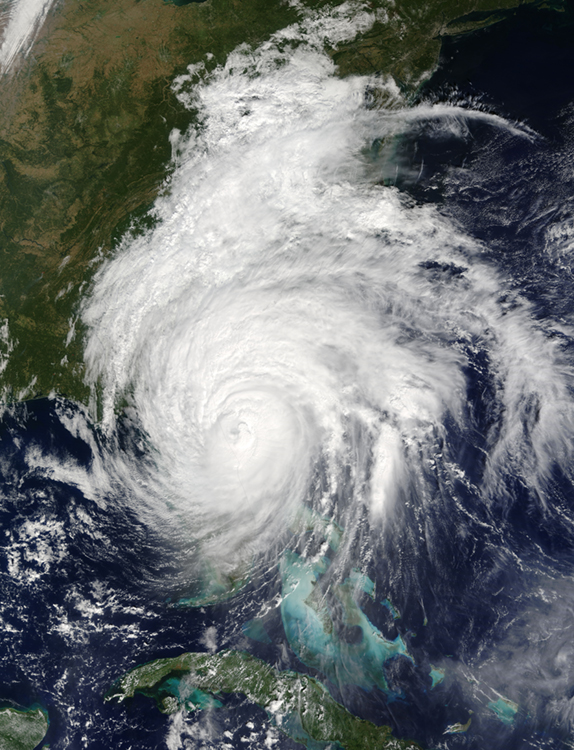
^A NASA satellite captured this image of Hurricane Matthew along the coast of Florida on Oct. 7, 2016. Credit: NASA’s Goddard MODIS Rapid Response Team
Hurricane Matthew formed as a tropical storm off the west coast of Africa in late September. The system strengthened as it prowled across the Atlantic Ocean, building into a hurricane as it entered the eastern Caribbean Sea. Peaking in strength at Category 5—the strongest hurricane rating with winds above 150 miles per hour (240 kilometers per hour)—Matthew scudded northwest and crashed into Haiti on October 4, devastating the country’s southwestern Tiburon Peninsula. Entire villages and farms were flattened or washed away, with contaminated water causing outbreaks of cholera. That same day, the storm lashed the eastern tip of Cuba, causing severe flooding in and around the city of Baracoa. Over the next two days, the storm rumbled over the Bahamas, doing its worst on Grand Bahama island just off the coast of Florida.
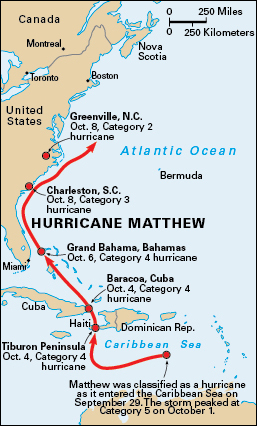
^Hurricane Matthew rolled through the Caribbean Sea and up the southeast coast of the United States in early October 2016. Credit: WORLD BOOK map
Hurricane Matthew then skirted the southeast coast of the United States, where mass evacuations had cleared many people from harm’s way. From October 7 through October 9, the storm caused flooding from Saint Augustine, Florida, up to Fort Pulaski, Georgia; Charleston, South Carolina; and inland into North Carolina and Virginia. Savannah, Georgia, recorded the highest rain total during the storm—more than 17 inches (44 centimeters). Around Greenville, North Carolina, flooding washed out highways and bridges, stranded motorists, and forced people to the roofs of their homes. In that state, boat and aircrews rescued more than 1,000 people—700 in central Cumberland County alone. Evacuations of coastal areas were fairly successful, but inland areas were often caught off guard. The storm also knocked out electric power for more than 2 million people and forced the closures of thousands of business and schools—including the Walt Disney World Resort in Orlando, Florida, which closed for just the fourth time in its history.
View more Behind the Headline stories in World Book Online!
When you need fast, reliable information for homework, reports, or just a lingering question, World Book Online is the place to go.
- A colorful, approachable look and feel, designed for kids, and articles written at your student's level
- Easy access on smartphones and tablets
- Five complete databases for multiple research levels
- Illustrations, maps, audio files, videos, eBooks, primary source documents, and more
Learn More | Buy Now